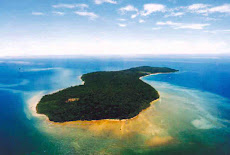
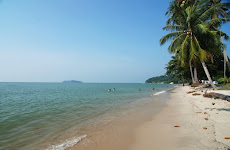
 Pulau Gaya is the largest island in Tunku Abdul Rahman Marine Park, it occupies an area of 15 square kilometres (3,700 acres). Several ridges, rising to more than 180m with a max of 300m, form the backbone of Pulau Gaya. This island is the closest in proximity to downtown Kota Kinabalu. The name “Gaya” is derived from the Bajau word "Gayo" which means big. Pulau Gaya is covered with dense virgin tropical forest. It has been a forest reserve since 1923. The island has hiking trails and a couple of small to medium sized resorts of which one is home to the Marine Ecology Research Centre. It is also host to a very large (and growing) stilt village located just opposite the KK waterfront. The major beach area on Gaya Island is located at the Police Bay. Over 400 metres of white sand gently slopes out to the sea making Police Beach an ideal place for swimming and snorkelling in crystal clear water. The coral reefs along the entire coast of the island are in excellent condition. The bay is nicely secluded, and the beautiful white sandy beach provides an excellent spot to relax after dives around the bay. Staghorn corals are predominant at depths from 10 to 20 metres and the terrain gradually slopes to a sandy bottom. Densely populated with small reef fishes, wrasses, nudibranchs and stingrays and if you are lucky, you may spot the odd lobster scavenging for food on the sandy terrain. Whale sharks have been seen just outside the bay which makes Gaya Island a dive destination underestimated by many tour operators and dive companies.
Sunday, 13 September 2009
Gaya Island, Sabah
Pulau Gaya is the largest island in Tunku Abdul Rahman Marine Park, it occupies an area of 15 square kilometres (3,700 acres). Several ridges, rising to more than 180m with a max of 300m, form the backbone of Pulau Gaya. This island is the closest in proximity to downtown Kota Kinabalu. The name “Gaya” is derived from the Bajau word "Gayo" which means big. Pulau Gaya is covered with dense virgin tropical forest. It has been a forest reserve since 1923. The island has hiking trails and a couple of small to medium sized resorts of which one is home to the Marine Ecology Research Centre. It is also host to a very large (and growing) stilt village located just opposite the KK waterfront. The major beach area on Gaya Island is located at the Police Bay. Over 400 metres of white sand gently slopes out to the sea making Police Beach an ideal place for swimming and snorkelling in crystal clear water. The coral reefs along the entire coast of the island are in excellent condition. The bay is nicely secluded, and the beautiful white sandy beach provides an excellent spot to relax after dives around the bay. Staghorn corals are predominant at depths from 10 to 20 metres and the terrain gradually slopes to a sandy bottom. Densely populated with small reef fishes, wrasses, nudibranchs and stingrays and if you are lucky, you may spot the odd lobster scavenging for food on the sandy terrain. Whale sharks have been seen just outside the bay which makes Gaya Island a dive destination underestimated by many tour operators and dive companies.


Subscribe to:
Posts (Atom)


